
Disregards Climate Science
Updated with New Sea Level Rise Analysis - April 2025
On April 8, 2025, the District released its draft Preliminary Endangerment Assessment (“PEA”), which contained data from the recent soil samples, as well as data about the impacts of sea level rise. This is what the report said about both the near-term (2020-2050) and mid-term (2060-2100) sea level rise risks:
Relevant Time Period
The current MVMS facility was built in 1969, so it has been in use for 56 years. Let’s assume this new building will need to last at least 50 years too. If it is completed in 2027, then it will need to last until at least 2077. Given this, the PEA’s near-term (2020-2050) and mid-term (2060-2100) analyses are both relevant planning factors.
Bay Area Sea Level Rise Projections
The PEA provides the following chart of Bay Area sea level rise scenarios (PEA, p. 66). The State of California requires public entities to plan for at least the Intermediate scenario (considered to be the most likely outcome), which means we must evaluate the impact of at least 1.4 feet of rise by 2070.

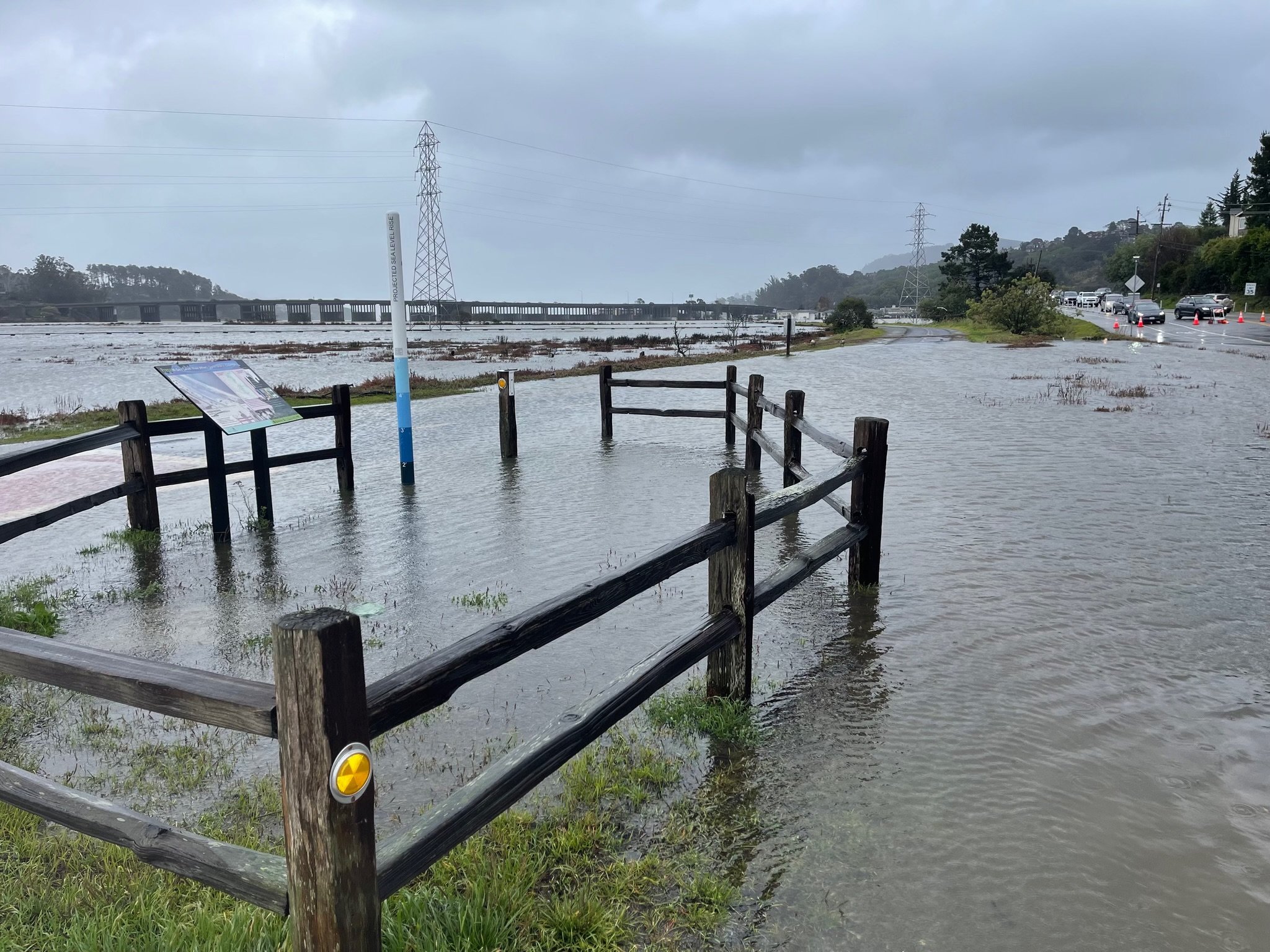
For reference, below is what 1.4 feet of sea level rise looks like. During King Tides and large rain events (like this 10-year storm on Dec. 13, 2024), Mill Valley already experiences about 1.5 feet of rise, as you can see from this marker here. This would be the new baseline, and King Tides and storms would be much deeper.
What does the Preliminary Endangerment Report Say About This?
This is how the PEA describes a 2050 scenario with just 1 foot of sea level rise: “A projected SLR of 1.0 foot would start overtopping the creek banks on the east side of the Site and minor flooding may occur on the eastern Site boundary adjacent to Pickleweed Inlet (Figure 18). Additionally, this would raise the groundwater elevation by approximately 1 foot and [contaminants of potential concern] that were previously only saturated during high tide and storm surge events, may now be permanently submerged and potentially increase the leaching of chemicals into groundwater and subsequently mobilizing contaminants.” (PEA 67).
This is how the PEA describes a 2060 scenario with 1.5 feet of sea level rise: “A projected SLR of 1.5 feet would increase the length of bank creek that would be overtopped and would begin overtopping the eastern Site boundary. Flooding would extend further west onto the Site and may begin to impact some school buildings that are located at lower elevations. The flood gate at the east side of the creek would likely no longer be sufficient and would be overtopped. Groundwater would rise approximately 1.5 feet and would be as shallow as 1.5 feet [below ground surface] in some places on-Site, nearly saturating all [contaminants of potential concern]-impacted waste in that area. The northeastern corner of the parking lot on the east side of the school would be permanently inundated with water. Any shallow contaminants may become saturated and mobile.” (PEA 67).
Where might this possibly leave our new school?
On an Island. The PEA explains, “Mid-term projections expect the perimeter of the Site to be inundated with water, essentially creating an island of the higher elevations at the center of the Site by 2100.” (PEA, p. 69)
A Potentially Toxic Island. “Impacts of groundwater rise associated with [sea level rise] could include submerging [contaminants of potential concern]-impacted waste that was previously above the water table and potentially increasing the concentration of contaminants that could leach to groundwater, and increasing the mobilization of contaminants. Groundwater rise would result in a reduction of the vadose zone, potentially pushing [contaminants of potential concern]-impacted soil vapor closer to the surface” (PEA, p. 69).
Picture This. The PEA discussed sea level rise, but did not specifically focus on the impact of storm surges, which can raise the total water level significantly, as we saw this winter. The following is a map showing the MVMS site using the assumption of 24” of sea level rise (plausible by 2070), plus a 5-year storm surge. You can explore the various scenarios with the ART Bay Shoreline Flood Explorer tool.


What are experts and organizations saying about this?
“I would not want to have a kid going to school, on a dump, while that waste is being inundated by water from below. Now that’s a good reason not to be on a contaminated site.”
—Professor Kristina Hill, Program Director, UC Berkeley Institute of Urban & Regional Development, speaking about Mill Valley Middle School on KQED, Schools in Deep Water: Bay Area Faces Uphill Battle Against Climate Change, Aug 5, 2024. Listen to the full episode!
“But even if the district raises the school above the area that will likely flood in the coming decades, climate scientists said it won’t take much more sea-level rise to turn the school periodically into an “island.” The school’s sea-level rise solution might protect the property, but the district’s choice to raise the school doesn’t fix the parents’ woes of getting kids to class on flooded streets.”
—KQED’s Ezra David Romero, describing Mill Valley Middle School in Rising Seas Already Flood Some Bay Area Schools. The Risk Will Only Get Worse, Aug 7, 2024. Checkout the full article.
“Bothin Marsh is threatened by rising seas and strong waves caused by climate change, and will also experience increased temperature changes and more frequent periods of drought and intense storms. Under these conditions, Bothin’s shoreline is in danger of eroding and the marsh may convert to mudflats or become submerged.”
—One Tam, Bothin Marsh – Sea Level Rise. Click here for more information about flooding on of the marsh surrounding MVMS.
What about flooding at the temporary campus? How bad could that be?
The proposed temporary site is on the eastern portion of MVMS’s campus, which is the most subject to flooding, as evidenced by the flood warning signs posted there. There is only one access road to this portion of the property. Even if the District raises the portables, it would, at best, create an inaccessible island for multiple days per year.


How many days a year might there be flooding at the temporary site? According to the nonprofit organization, One Tam, tidal flooding happens around 30 times a year currently. With only 1-foot of sea level rise, “flooding could occur over 220 days a year, drowning the marsh and making the bike pathway impassable!” Even under the current scenario, 30 days of flooding at the temporary campus could make life difficult for students, staff, and families, even if the portables are raised. There is the pesky matter of getting there…
Video taken from the bike path by the Sewer Treatment Plant, looking toward the Skate Park, the proposed site for the temporary campus. The single access road to campus would be hard for cars to navigate safely, and the flooded bike path would be hard for students to traverse safely, whether on foot or bike.
Collaboration is Key
We need an all-hands-on-deck approach to planning for sea level rise. Building MVMS on elevated pylons is not going to solve this problem. Assuming that the problem is someone else’s responsibility is not going to solve this problem either. The District needs to be an active partner in the ongoing work with the City of Mill Valley and the County of Marin, to help create a multi-jurisdictional plan to address sea level rise flooding. That is the best path toward a sustainable place for our students to learn.